Who will be affected?
Water is one of the four basic elements of life. Culturally and socially, water takes on its own personality when discussed by various anthropological groups. Merriam-Webster’s Dictionary defines water as “the clear liquid that has no color, taste, or smell, that falls from clouds as rain, that forms streams, lakes, and seas, and that is used for drinking, washing, etc.” [14]. That definition could be qualified as a solely scientific response – it has no reference as to how water is essential for all life forms on Earth. Native American tribes, specifically the Navajo living here in the southwest, have a more instinctual definition: “Tó éí iína” (Water is life) [19]. Another Navajo saying is: Tó éí be’iína át’é (Water is essential for life to exist). A Wisconsin Native American tribe, the Ojibwe have cultural traditions that relate to water; “water has a spiritual component that gives it a key role in stories, ceremonies, religious practices, and daily life.” [15]. Westerners, on the other hand, have a more utilitarian view of water and its sources: “Noted river adventurers Richard Bangs and Christian Kallen suggested rivers are “arteries of the planet” that have utilitarian value (i.e., expansion of civilizations) and are important in sustaining biological diversity and human civilization” [5]. The practicality of water is currently demonstrated in our daily lives – we divert it for drinking water, household uses (laundry, bathing and kitchen), and agriculture as well as for the industrial arena. This social and cultural background of water needs to be explored when dealing with desalination. Whether in the form of Reverse Osmosis, which is highly energy intensive, or in the form of Passive Solar, which is highly beneficial for Arizona, desalination will be needed in the future. Because it is an up-and-coming technology, the views and ideals of the main stakeholders (i.e., the general public) will be monumental in laying the groundwork for the future.
Who will be provided for in this plan?
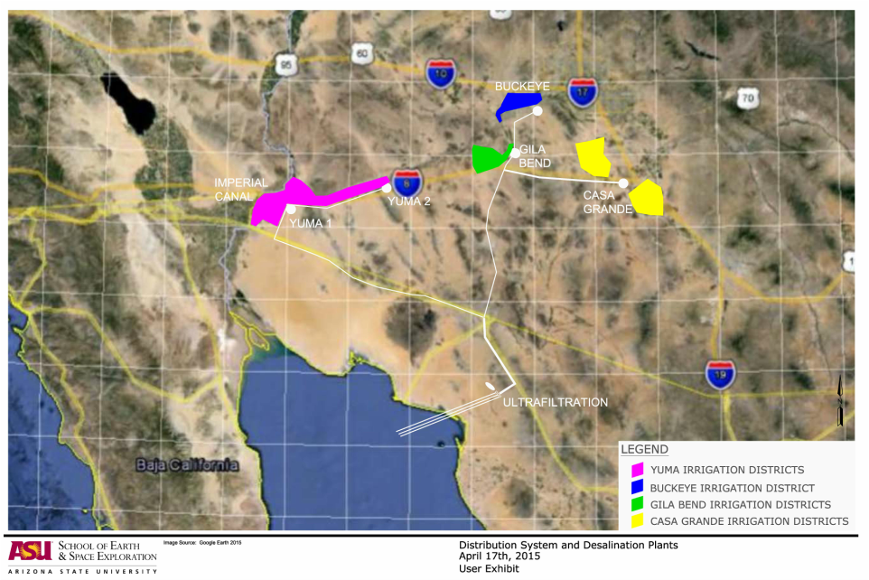
Irrigation districts in the Yuma, Gila Bend, and Casa Grande regions have been thoroughly mapped and labeled. Yuma consists of nine irrigation districts [1] , while Casa Grande consists of five [7] . Gila Bend does not have official irrigation districts and relies heavily on groundwater. These districts have provided ample information regarding how much water is utilized in the area for irrigation and how these trends change over time. Irrigation districts have been an integral part of the research because the project targets areas using non-potable water sources.
The City of Yuma, AZ is the hub for distribution into Arizona and California. Yuma possesses extensive pre-existing canals and dams that will enable the project to save money and time [4][18] . Yuma currently uses 1-1.5 million acre feet (MAF) of water per year for irrigation purposes. Currently, Yuma County is the number one vegetable producer in the state of Arizona and number three in the nation. They produce 90% of the leafy greens used by the nation between the months of November and March [6] . At this time, Yuma utilizes groundwater and Lower Colorado River Water (which tends to be too saline), which the project looks to replace with desalinated water from Mexico. The same can be said for the Imperial Valley region of California [22]. In addition, the project will look to supply water to this region, as it has been plagued by drought in recent years. This will add another 0.5 MAF per year to the amount of water being brought into the Yuma area. The delivery of water will take place via Yuma and the All American Canal.
Initially, the project aims to supply water to two different regions. Phase One will supply water to Yuma, AZ, and its surrounding areas, as well as Imperial Valley, CA. The amount of water supplied will total 1.5-2 MAF per year. Phase Two will supply water to Gila Bend, AZ, and its surrounding areas. The amount of water supplied will total 0.5 MAF per year in the form of recharge into local aquifers. Phase 3 and beyond, seek to supply water to areas in need of the water and that are available to contribute to installation costs.
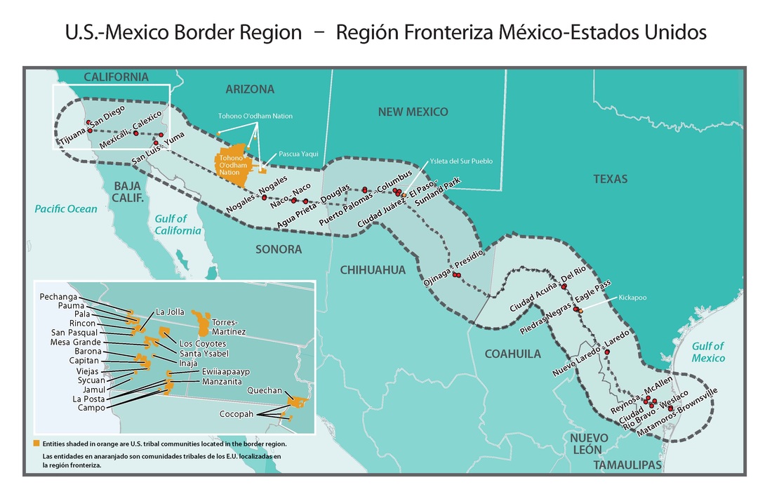
Consideration of the Environmental Protected areas plays a crucial role when determining where an outside project will be routed [12][3] . Arizona and Mexico have unique flora, fauna, and geology that is special to the Southwest. Arizona itself has over 300,000 acres of protected areas.
The imperial dam lies 18 miles northeast of Yuma. The structure retains Colorado River water that gets desalinated and distributed to both California and Arizona [13] . Looking at the amount and the locations that the water gets dispersed served a purpose when determining where the desalinated Baja Mexico should go.
Native American lands and wildlife preserves are spread broadly across the state and Sonora, Mexico, and will require lengthy negotiations to route through these lands. These areas have been identified and taken into account, as can be seen in related maps. It has been difficult to find areas of land that are large enough to hold the six desalination plants, energy supplies, and piping that do not conflict with ecologically sensitive areas, Native American reservations, military, and private land [6] .
Who is impacted by this plan?
|
Inequity in raising Domestic Water User Fees The balancing act of providing fresh water at affordable prices in these times of drought is becoming more and more challenging. Traditional sources of freshwater are overdrawn, and non-traditional sources, such as sea-water desalination, is an expensive prospect. To use traditional supply and demand models to determine the cost of a gallon of water creates great inequity between the rich and the poor. To raise the price of a gallon of water without considering a basic amount for survival (washing and cooking) creates an environment where the very poor pay a significantly higher percentage of their income than the rich [17] . The State of California is in an unprecedented drought and the Governor of California has issued Executive Order B-29-25 [2] to reduce the potable urban water use by 25% with the intent to save 1.5 Million acre feet. The largest user of California’s fresh water resources, agriculture, is notably excluded from the current water savings plan. As water prices rise due to continuing drought, for the purposes of equity, it is important to implement larger increases on high volume users and maintain a low cost minimum water usage. [16] |
|
Who will be employed?
|
In the long term the important jobs in the industry are the laborers that install, operate, and maintain the equipment at the plant. The entire industry of Industrial construction and renewable energies are growing and will continue to grow in the coming years. As the demand for water increases so will the need for jobs and energy. There are three different phases of occupations in this industry which are manufacturing, project development, and operation and maintenance [9]. Many jobs throughout the industries already exist. Some positions require specific training and usually a certification or degree [8]. There are a handful of engineers in all three phases. These jobs can earn anywhere from $70,000 or more annually [9]. In the manufacturing phase the occupations range from machinists to quality testing. Their wages differ but start at around $30,000 annually [8]. In the project development phases the jobs range from scientists that examine the ecosystem of the site to construction laborers [9].The wages for this phase have the largest gap and ranges from $30,000 - $100,000 annually [9] . Chemists, physicists, and materials scientist also are involved and will earn wages from around $68,000-$106,000 annually [9]. So overall many different skills are involved in the creation of this project and this will create many jobs in Arizona as well as In Mexico. |
|
Who are the Federal Agency Stakeholders?
|
The U.S. and Mexico have cooperated on their shared border environment for over a hundred years. The United States and Mexico established the U.S.-Mexico Border Environment Cooperation Agreement, formally executed as the Agreement Between the Government of the United States of America and the Government of the United Mexican States Concerning the Establishment of a Border Environment Cooperation Commission and a North American Development Bank, signed November 16 and 18, 1993 and subsequently amended through Protocol of Amendment signed November 25 and 26, 2002, which entered into effect on August 6, 2004. This international agreement created the Border Environmental Cooperation Commission (BECC) and the North American Development Bank (NADB) [4] . The Border Environmental Cooperation Commission (BECC), which identifies, develops, and certifies environmental infrastructure projects in the the U.S.-Mexico border area.The U.S.-Mexico Border Water Infrastructure Program provides funding for the development of critical environmental infrastructure along the U.S.-Mexico border region, defined as 100 km (62 miles) north and 100 km south of the U.S.-Mexico border. The International Boundary and water Commission (IBWC), is a U.S.-Mexico international organization with a presence in both countries. Established in 1889, the IBWC is an international body composed of the United States Section and the Mexican Section. Their mission is to provide binational solutions to issues that arise during the application of United States - Mexico treaties regarding boundary demarcation, national ownership of waters, sanitation, water quality, and flood control in the border region. The Treaty of February 3, 1944 for "Utilization of Waters of the Colorado and Tijuana Rivers and of the Rio Grande" provides that of the waters of the Colorado River there are allotted to Mexico: (1) a guaranteed annual quantity of 1.5 million acre-feet to be delivered in accordance with schedules formulated in advance by Mexico within specified limitations; and (2) any other waters arriving at the Mexican points of diversion under certain understandings. To enable diversion of Mexico's allotted waters, the Treaty provided for the construction by Mexico of a main diversion structure in the Colorado River, below the point where the California-Baja California land boundary line intersects the river. It also provided for the construction at Mexico's expense of such works as may be needed in the United States to protect its lands from such floods and seepage as might result from the construction and operation of the diversion structure. [10] The Environmental Protection Agency (EPA) enforce the rules and regulations regarding environmental policy in the United States. Mexico has an EPA counterpart known as SEMARNAT. The Secretariat of Environment and Natural Resources (SEMARNAT) is the federal agency responsible for promoting the protection, restoration and conservation of ecosystems and natural resources and environmental goods and services in Mexico, in order to promote their sustainable use and development . They also enforce rules and regulations regarding environmental policy. |
|
Who can assist with resources regarding desalination?
The International Desalination Association (IDA) is the world’s leading resource for information and professional development for the global desalination industry – and the only global association focused exclusively on desalination and desalination technologies. A non-profit association, IDA is associated with the United Nations as part of a growing international network of non-governmental organizations (NGOs). [11]
30 Member Board of Directors
Assures that the global desalination community is properly represented within the associations leadership, between regions (Europe, Latin America, Middle East, Africa, North America, Pacific and Asia).
References
[1] Arizona Department of Water Resources, (2015). Arizona Irrigation Districts. [online] Available at: http://www.azwater.gov/azdwr/GIS/documents/irrigationdistricts.pdf. [Accessed 16 Feb. 2015].
[2] Brown, E, 2015 Executive Order B-29-25 Executive Department State of California
[3]Environmental Protection Agency. US-Mexico Border 2020 Program,2015. Available from http://www2.epa.gov/sites/production/files/documents/Border2020-map.pdf [9 April 2015]
[4] EPA United States Environmental Protection Agency, Water: U.S. Mexico Border Program 2013. Available from http://water.epa.gov/infrastructure/wastewater/mexican/program_history.cfm [9 April 2015]
[5] Forest Service, U. (2015). Water and People: Challenges at the Interface of Symbolic and Utilitarian Values. 1st ed. [ebook] USA: United States Department of Agriculture, p.147. Available at: http://www.fs.fed.us/pnw/pubs/pnw_gtr729.pdf [Accessed 10 Apr. 2015].
[6] Gis.azland.gov, (2015). EVO. [online] Available at: http://gis.azland.gov/webapps/parcel/?loc=-114.1719,32.6379,10&layers=3,2,0. [Accessed 3 Apr. 2015].
[7] Gcairoinc.com, (2015). George Cairo Engineering. [online] Available at: http://www.gcairoinc.com. [Accessed 30 Mar. 2015].
[8] Hamilton, J. (2011). Careers in Solar Power. [online] Bls.gov. Available at: http://www.bls.gov/green/solar_power/ [Accessed 10 Mar. 2015].
[9] Hamilton, J. and Liming, D. (2010). Careers in Wind Energy. [online] Bls.gov. Available at: http://www.bls.gov/green/wind_energy/ [Accessed 10 Mar. 2015].
[10] International Boundary and Water Commission United States and Mexico United States Section, The International Boundary and Water Commission - Its Mission, Organization and Procedures for Solution of Boundary and Water Problems, Available from http://www.ibwc.gov/About_Us/About_Us.html. [11 April 2015]
[11] International Desalination Association, About 2014. Available From http://idadesal.org/about/ [11 April 2015]
[12] Land.az.gov, (2015). [online] Available at: https://land.az.gov/sites/default/files/styles/large/public/state.png [Accessed 1 Apr. 2015].
[13] Iid.com, (2015). Imperial Irrigation District : All-American Canal. [online] Available at: http://www.iid.com/index.aspx?page=177. [Accessed 3 Mar. 2015].
[14] Merriam-webster.com, (2015). water | the clear liquid that has no color, taste, or smell, that falls from clouds as rain, that forms streams, lakes, and seas, and that is used for drinking, washing, etc.. [online] Available at: http://www.merriam-webster.com/dictionary/water [Accessed 10 Apr. 2015].
[15] Reynolds, G. (2015). A Native American Water Ethic. 1st ed. [ebook] p.147. Available at: http://eps-spring2014course.wikispaces.com/file/view/Reynolds.pdf [Accessed 10 Apr. 2015].
[16] Rita Martins & R, Cruz, L & Barata, E & Quintal, C 2013 ‘Assessing social concerns in water tariffs’ Water Policy vol. 15, no.2, pp. 193-211
[17] Sebri, M 2015 ‘Water affordability and social equity in Tunisian governorates: a distributive approach.’ Water Policy vol. 17, no.1, pp. 26–45.
[18] Securing Arizona’s Water Future, n.d., Available from: http://www.azwater.gov/AzDWR/PublicInformationOfficer/documents/supplydemand.pdf. [18 March 2015].
[19] Semken, S. (2015). Water is Life in the Southwest. 1st ed. [ebook] Tempe: ASU, p.2. Available at: https://myasucourses.asu.edu/bbcswebdav/pid-9380201-dt-content-rid-42494106_1/courses/2014Fall-T-GLG301-SOS372-79661-83824/esas1201_WaterSw_I.pdf [Accessed 10 Apr. 2015].
[20] Team, R. (2015). Facilities by state - Bureau of Reclamation. [online] Usbr.gov. Available at: http://www.usbr.gov/projects/FacilitiesByState.jsp?StateID=AZ#list. [Accessed 3 Mar. 2015].
[21] Team, R. (2015). Project details - Boulder Canyon Project - All-American Canal System - Bureau of Reclamation. [online] Usbr.gov. Available at: http://www.usbr.gov/projects/Project.jsp?proj_Name=Boulder+Canyon+Project++-+All-American+Canal+System. [Accessed 1 Mar. 2015].
[22] Yuma County: America’s Winter Vegetable Capital. Available from: http://arizonaexperience.org/land/yuma-county-americas-winter-vegetable-capital. [5 April 2015]
